


The Texas Hill Country is my home
When Disaster Strikes

I’ve read and heard many opinions about what happened in Kerrville and the surrounding communities last weekend in the Hill Country of Texas. Mostly from people who’ve never been there. The people that have been there are offering their prayers, their time, and their treasure in an attempt to help after an unthinkable tragedy.


Much like what happened in Asheville, North Carolina. What happened in Pacific Palisades, California. What has happens repeatedly along the gulf coast of Florida and the coastal plains of the low country of South Carolina.
People from other parts of the country or the World attempt to lay blame at the feet of leaders with which they differ politically.
Fuck those people. The people I will listen to are the locals. The folks that choose to live in these areas because of family, legacy, beauty, and lifestyle—and yes, the risk. I am one of those people that knows and understands the beauty and magic of the region of Texas called The Hill Country.
I first visited this area nearly 50 years ago. A group of my fellow students at SMU made the 4+ hour drive down from Dallas one summer to float the Guadalupe River near Sattler—the prime location for this type of activity along the meandering 250-mile path of the well-known river in Central Texas—because that stretch of river is flood controlled. The Guadalupe has one flood control mechanism along its entire path—Canyon Lake and the Canyon Lake Dam. The river above it is wild in its basin. The river below the dam comes out of the bottom of the dam, cold and clear and the perfect antidote to a hot and humid Texas summer day. That day 50 years ago we rented our innertubes from a local vendor, including one for our ice chest full of cold beverages, and burned our fronts while our rumps stayed chilly in the water for the next 6-7 hours of pokey floating. It is a tradition that millions of Texans have taken part in for the last century. I’ve done so many times since, kayaking with my brother, and taking the dogs there often for swim and play in the slow-moving, crystal-clear waters.


I chose to move to the region nearly 10 years ago in search of a simpler and more natural, rural way of living in an area dominated by small communities. My friends thought I was nuts to give up 25 years in Colorado for rural Texas. I’d spent most of that time in the city of Denver. I’ve written previously about the changes that had come to Denver. There is no doubt that solitude and incredible beauty exists within a short drive of Denver, but that had become increasingly crowded and difficult. Facing retirement, I chose to escape the increasing craziness of the urban landscape, and I’ll never regret it. In Wimberley, Texas—a small vibrant and creative community on the Eastern edge of the common geological and geographical boundaries of the Hill Country—I found land, community spirit, and chance at rebirth. I also found two-lane roads, low water crossings, massive live oaks, and centuries-old Cypress trees along meandering spring-fed creeks and rivers. There is a difference between traveling to these places and actually living in them. IYKYK.
Many areas of the country have their own “summer on the river” destinations. Few of them these days aren’t flood controlled in some way thanks to the overly aggressive Corps of Engineers dam-building efforts of the mid-twentieth century. Rain-related flooding is a fact of life in these areas that depend on a river for their farming, their commerce, and their recreation-based tourism.
We see news every year about an area of the US—or other parts of the World—has flooded and caused destruction and heartache to its residents and guests. The national news cycle pays attention for a minute then moves on. The locals meanwhile are left with the unimaginable trauma of loss and rebuilding. This intense period includes grieving, therapy, battles with insurance companies, lectures from local officials, outrage and protests about why we weren’t better warned or protected. What generally shines through all of the chaos is the spirit of volunteerism, the dedication of first responders, and the gigantic charitable hearts of Americans. This is the phase of the disaster that my region is now involved in. Along with the unspeakable and everlasting trauma of finding the bodies of family members, friends, neighbors, and pets.
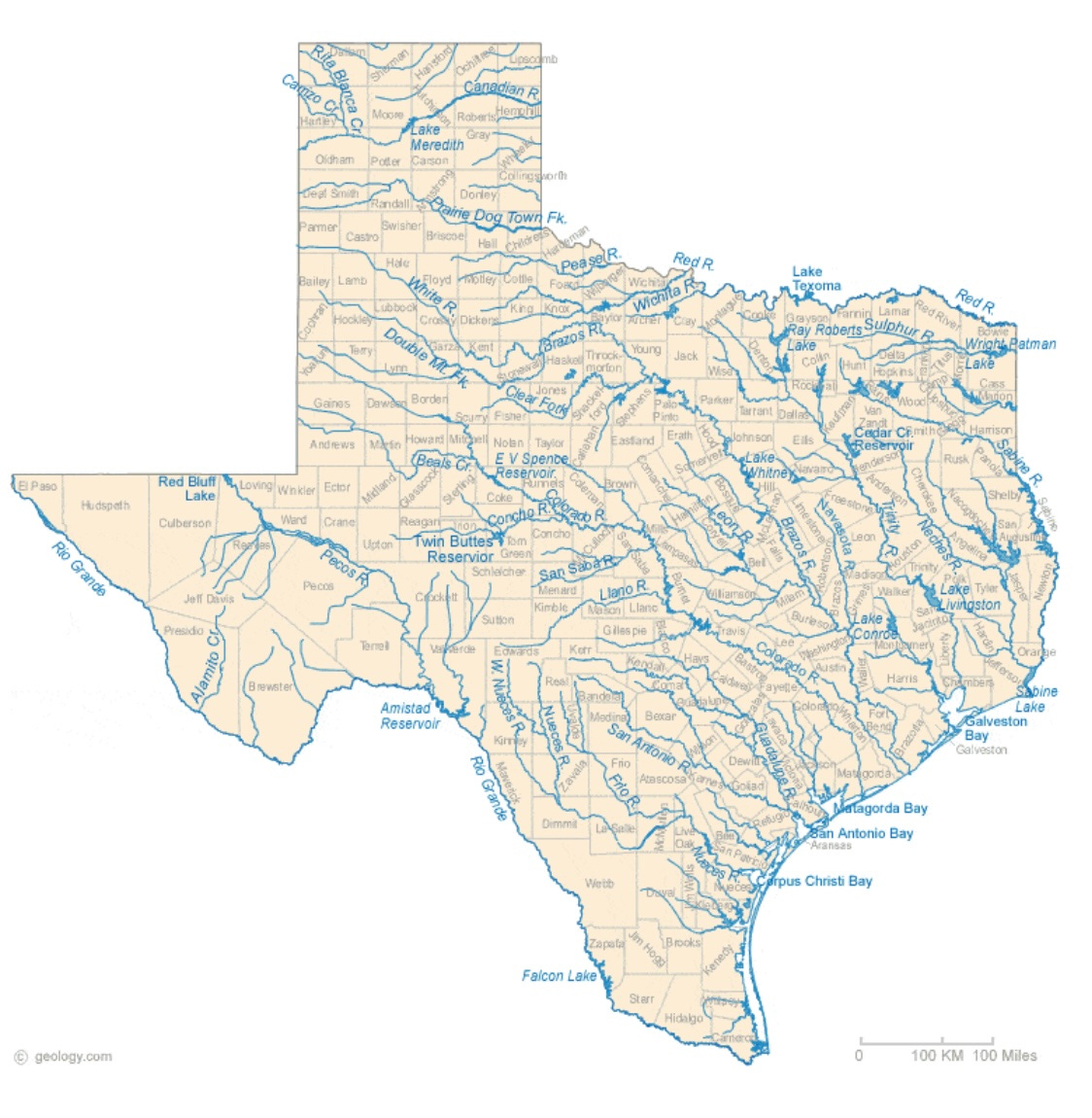
The counties of Central Texas are in what is called “Flash Flood Alley.” A map of the area quickly illustrates why. The vast reaches of Texas are broken into many different geological regions. The northwest corner of Texas is high elevation—the southern reaches of the Colorado Plateau. The barren and dry desert-like expanses of West Texas folds into the Llano Estacado—or Staked Plains—which was the former buffalo hunting grounds of the fearsome Comanches bands that controlled the plains during the 16th and 17th centuries. Further south the escarpments create the fall in elevation and the beginning of many of the rivers that flow side by side southeast through Central Texas to the gulf of America.
The region called Central Texas is alternatingly wet but mostly dry. As locals like to say, the weather history of the region is extended droughts interrupted by occasional floods. I’ve written about my town of Wimberley’s own tragic flood experience in 2015 here in a previous essay.
I’ve also written about my own experiences as a homeowner with drought, wells, and rainwater capture as a solution here. Underground aquifers provide the groundwater for most of this region. These many spring-fed creeks and rivers feed the aquifers just as the aquifers feed back to the tributaries. Water wells are the primary source for most rural residents. Even the towns that have a municipal water system rely on wells pumping from the aquifers to provide the municipal water to its customers. Rainwater capture is becoming a viable alternative in recent decades, and more and more residents—including my family—have chosen to rely on rain as their primary or only source of household water.
When rain comes in this part of the country, it’s like a big cow pissing on a flat rock. It’s copious, loud, and it goes everywhere. Intense rain, thunderstorms, hail, and periodic tornadoes are part of the Spring weather patterns.
What made last week’s event—as well as the one my town suffered through 10 years ago—so damaging was a combination of events coming together in a perfect storm. Yup I said it. The Wimberley floods of 2015 happened on a crowded Memorial Day weekend. The Kerrville floods last week happened on a crowded 4th of July weekend. What’s up with Holiday weekends?
The deadliest floods in Texas history are Galveston in 1900 (estimated 8,000 to 12,000 died) as well as San Antonio in 1921 (220 died) and 1913 (180 died). Official numbers for the July 4 floods are currently over 120 and people remain missing, but it is likely to be one of the worst.
Central Texas is defined by most as the 15 counties centered around Austin. For some purposes there are 20 others further West that are considered as well. San Antonio sits with one foot in Central Texas and the other foot in South Texas stretching down to the gulf. If you can imagine the area, draw a line southwest from Austin to San Antonio directly down the Interstate 35 corridor connecting the two, and look due west for 100 miles—that is The Hill Country.
To say that Texans understand that flash flooding is a constant risk would be to minimize it. You cannot live here and not be hyper-aware of the constant risk. Below is a history (not complete but covers the major incidents) of flash flooding in Central Texas.
Timeline data below pulled from Jonathan Burnett’s book “Flash Floods in Texas” (Texas A&M Press 2008). No part of Texas is immune to flash floods," Burnett writes. The state lies in the path of sources of copious moisture from the Gulf of Mexico and the Pacific Ocean. Hurricanes and tropical storms frequently visit our state and release enormous amounts of water as they dissipate over land. Slow-moving cold fronts and the Texas dry line interact with the jet stream to build supercells that can drop torrential amounts of rain in a very short time. Compounding their threat, these supercells have a tendency to strike at night, when the flash flood danger is hidden in darkness.
April, 1900
Location: Colorado River
Rainfall: 6.5 inches near Austin, much greater amounts upstream
Rise: Peaked at 47 feet near La Grange
Impact: Austin Dam collapsed; a 40-foot wave struck the dam’s powerhouse killing eight workers. In total, 47 people died in the flood, 18 of them in Austin. Outstanding bond investment lost on the dam: $1.3 million, out of $14 million in overall damages. The triple-decker pleasure boat Ben Hur, which had plied Lake McDonald above the dam, broke into pieces. Floodwaters spread to a width of 12 miles far downstream in coastal Matagorda County.
November 20-December 5, 1913
Location: Nolan Creek in Belton, as well as rivers to the south and north, including the Brazos
Rainfall: Up to 14 inches
Rise and Flow: A flood wave hit Belton on Dec. 2, causing catastrophic damage. The same weather inundated Austin, covering all the south shore of the Colorado River in floodwaters. Parts of Bastrop were under 2 to 3 feet of water. Estimated average daily discharge at one point downstream: 380,000 cubic feet per second.
Impact: The floods caused destruction far and wide; in Austin, talks began in earnest about the next iteration of flood-control dams upstream.
April 18-26. 1915
Location: Temple to San Antonio, including Austin
Rainfall: Up to 19 inches in Austin, 10 inches on April 23 alone
Impact: The floods scoured structures crammed into the Shoal and Waller Creek canyons, and the debris from local creeks merged in the Colorado River. At least 32 people died; nearly 1,000 were displaced; bodies were found miles downstream.
September 9-10, 1921
Location: San Gabriel River watershed was the worst hit.
Rainfall: An astonishing 38 inches fell on Thrall, a longtime national record; 25 to 30 inches elsewhere
Rise: Up to 45 feet during a 12-hour period at Cameron
Impact: More than 200 Central Texans died, most of them in San Antonio, then the biggest city in Texas. Roads were impassible for weeks.
July 1932
Location: Guadalupe, Frio and Comal rivers, as well as the rest of the Hill Country
Rainfall: 21 inches recorded at Uvalde; reports of up to 26 inches elsewhere over the course of two days.
Rise and flow: At Kerrville, floodwaters reached 39 feet. Peak discharge: 62,800 cubic feet per second on the Guadalupe at Spring Branch.
Impact: Cabins washed away at Camp Mystic, Camp Rio Vista and Camp Stewart. Water inundated the dining hall at Camp Waldemar. Amazingly, no campers were lost in this flood, which became the benchmark along the Guadalupe; summer camps were hence moved above the 1932 flood line.
June 1-18, 1935
Location: Llano, Nueces, Colorado and Frio rivers
Rainfall: Spread out over weeks, daily totals remained under 3 inches throughout the Hill Country. Cumulatively, however, that prolonged precipitation produced a lot of rain-soaked land and rushing water.
Rise and Flow: Rise up to 40-foot stage in Austin, well over the Congress Avenue Bridge; discharge peaked at 46,700 cubic feet per second on the Llano River and a shocking 333,000 cubic feet per second on the Colorado in Austin on June 15.
Impact: Detritus from upstream gathered in Austin. Logs were piled waist-high in Zilker Park. The 1935 flood pushed federal officials to speed up the approval process for more flood-control dams on the Colorado River.
September 13-18, 1936
Location: Concho and Colorado rivers
Rainfall: Up to 15 inches
Flow and Rise: Multiple floods hit in waves on Hill Country rivers. The Colorado River’s average daily discharge peaked at 166,000 cubic feet per second in Austin on Sept. 28. The rise on the Concho River peaked at 43.6 feet.
Impact: San Angelo was particularly hard hit. Eyewitnesses said it “looked like a seaport.” Ironically, San Angelo had become the Tom Green County seat after an 1882 flood wiped out Ben Ficklin, the previous county seat, and killed 65 people.
July 9-30, 1938
Location: Brady Creek and San Saba River
Rainfall: Farmers and ranchers cheered, hoping for relief from the 1930s drought, but some got more than they bargained for; 17 inches in Eden and 22 inches in Sloan, all of it headed down to the San Saba and, eventually, the Colorado.
Rise and Flow: The San Saba River peaked at 22.7 feet. Average daily discharge reached 254,000 cubic feet per second on the Colorado River in Austin.
Impact: The release of water from gates on the new Buchanan Dam sent a destructive wave down the Colorado, which the Austin American newspaper called “a man-made flood.” The actions provoked a study of the dam’s efficacy.
September 9-11, 1952
Location: Hill Country
Rainfall: As much as 26 inches (some thought it would end the major drought of the 1950s, which persisted for years)
Rise: Lake Travis rose 57 feet in less than 24 hours, filling it for the first time in seven years. The lake’s volume tripled in 24 hours.
Impact: Wiped out the U.S. 281 bridge over the Pedernales River in Johnson City.
May 9-14, 1957
Location: Lampasas River
Rainfall: More than 8 inches in Lampasas
Flow: Peak average monthly discharge at Belton in May 1957: 180,000 in cubic feet per second.
Impact: The flood swamped 68 blocks in Lampasas, destroying 38 houses and five businesses; 46 houses and 47 businesses sustained major damage. Ninety percent of the downtown district was affected. The official damage estimate amounted to $4.5 million.
May 13-16, 1970
Location: San Marcos River
Rainfall: Peak of 18 inches (May 14-15) at one station in San Marcos
Impact: The water surge overwhelmed a third of the city, but it was not as bad as it could have been, because the Blanco River, a tributary of the San Marcos, did not flood. A dramatic scene unforlded at Travis Elementary: 150 children marooned in their school building. Up to 30 alligators from Aquarena Springs were reported to be on the loose.
May 5-15, 1972
Location: Comal and Guadalupe rivers
Rainfall: Some New Braunfels residents reported 12 inches of rain in one hour on May 11. At the center of the storm, 16 inches fell within four hours.
Flow: Houses floated downstream with residents atop. Many rescues and attempts.
Impact: The new Canyon Dam, upstream on the Guadalupe River, did not exempt the city from damage. Damage to Dry Comal Creek, Blieders Creek and the Comal River area was estimated at $3.3 million.
July 30, 1978
Location: Hill Country
Rainfall: A total of almost 20 inches in Hunt, 17 inches in Kerrville from the remnants of Tropical Storm Amelia.
Flow: On Aug. 1, average daily discharge rose to 74,200 cubic feet per second on the Guadalupe River at Comfort. At Spring Branch, it rose to 160,000 cfs on Aug. 3, and the river crested at 42.25 feet.
Impact: The Medina River Valley was hit hard, but once again the Guadalupe River lived up to its reputation for dangerous flooding. In Kerr, Kendall and Bandera, 27 people died. Gov. Dolph Briscoe called the flood “the worst in Texas history.” The National Weather Service concluded: “The death toll in last week’s tragic Hill Country flood could have been reduced if the NWS had provided better warning.” Other critics suggested that, at some point, human activity should be restricted from dangerous flood zones.
May 24, 1981
Location: Austin, Shoal Creek
Rainfall: From 4 to 10 inches of rain, depending on location, was enough to cause severe damage along Shoal Creek, most of it downtown near Fifth and Sixth streets, where the creek’s canyon suddenly widens.
Flow: Saturated soils contributed to the sudden flash flood.
Impact: Thirteen deaths across the city; cars swept downstream; $35.5 million in damage. The shocked city instituted flood control projects, including limits on impervious cover, which had increased the rapidity of the flood’s flow.
July 16, 1987
Location: Guadalupe River
Rainfall: Slow-moving thunderstorms near Comfort sent a surge of water down the Guadalupe River.
Impact: A stalled church bus from the Pot O’ Gold Christian Camp trapped campers, 10 of whom died in the Guadalupe River. Thirty-three others were injured.
December 18-31, 1991
Location: All over Texas
Rainfall: El Niño pushed storms across the state, bringing 12-15 inches of rain to the Hill Country.
Flow: Lake Travis rose to 710 feet, an all-time high, within four feet of overtopping Mansfield Dam.
Impact: Downstream, the damage was even worse. From Bastrop to the Gulf of Mexico, Colorado River towns saw some of the most brutal flooding in modern memory.
October 28, 1996
Location: Llano River
Rainfall: About 19 inches fell on the basin upstream of the town of Llano.
Rise: The Llano rose to 31 feet, the highest stage since the 1980 flood.
Impact: Downstream, the Llano and Colorado rivers rose rapidly. This story was repeated in later flood seasons. The Llano is one of the state's least controlled rivers, and also one of its most beautiful.
October 17-21, 1998
Location: Hill Country
Rainfall: Two hurricanes pushed excess moisture into the Hill Country. The highest total rainfall was more than 23 inches in New Braunfels.
Flow: The San Antonio, San Marcos and Guadalupe rivers flooded, as did every creek in their basins.
Impact: More people and development meant more destruction along Hill Country rivers.
June 30-July 11, 2002
Location: Guadalupe, Little, San Gabriel and San Antonio rivers
Rainfall: Up to 27 inches in Comfort
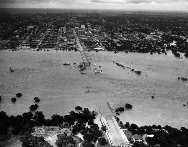
Impact: Water raged over Canyon Dam spillway for the first time in history, creating a new path for the floodwater; residents along the river below the dam evacuated. Total event damage estimated at $2 billion.
October 31, 2013
Location: Onion Creek
Rainfall: In some places, more than 10 inches
Rise and Flow: The creek, which flows mostly west to east, crested in South Austin at 41 feet. The previous record, set in 1869 and in 1921, was 38 feet. At one point, it rose 11 feet in just 15 minutes. The flow rate was clocked at 120,000 cubic feet per second.
Impact: Four people believed dead. Hundreds of homes were damaged, many of them severely. Dozens of the residences in the floodplain were later purchased by the city of Austin and some remains now form ghost neighborhoods along a greenbelt.
Memorial Day weekend, 2015
Location: Blanco River
Rainfall: As much as 10 inches
Flow: A 40-foot crest meant that anyone still near the river had little time to escape.
Impact: Thirteen people died in the Wimberley area. The quiet valley — cabins, vacation homes, vehicles, ancient trees scraped away by violent water — was devastated.
Fourth of July weekend, 2025
Location: Hill Country
Rainfall: Remnants of Tropical Storm Barry dropped as much as 20 inches on parts of the Hill Country
Rise: The Guadalupe River rose 26 feet in 45 minutes and crested at 37 feet in Hunt and 39 feet in Kerrville. The San Gabriel River crested at 41 feet; the San Saba River at almost 30 feet.
What makes this flood burn into the national conscience so deeply?
Kids dying.
A holiday weekend.
The nasty black hole that is social media.
A lot of idiots irrationally hate Texas and Texans.
Political division.
Let’s take it back one week to Friday the 4th of July. Locals that live in these areas are hosting friends and family from out of town, drawn by the cool clear waters. Visitors flock to these areas from Texas’ major urban areas like Houston, San Antonio, Dallas, and Austin. People are leaving their phones in the house, paddling around in the water, camping, BBQing, and celebrating a holiday weekend off work and away from responsibilities—and in many cases they’ve been doing the same things in the places on the same weekends for generations. Same scenario ten years ago in my town. It’s a holiday weekend.
In Wimberley’s 2015 flood, eight of the eleven fatalities were all from the same family—all in the same house—that broke free from its slab, floated down the swollen river, and broke apart on a bridge. These are people that had been enjoying that same house on hundreds of summer weekends for three generations. The sole survivor in that particular tragedy lost his wife, father, mother, sister, brother-in-law, his two young children, and a nephew. He and the family dog survived. He has said repeatedly in memorial events that he wished he had gone down with them. Unimaginable tragedy.
Warnings:
There has been much criticism about what and why could have or should have been done to warn these people. Given all I’ve just outlined for you in the copious text above, there is already an inherent warning built into being riverside in Central Texas. The long dry periods lull one into a sense of complacency. The Blanco River in my town barely flows but a trickle most of the year—most years. Until it doesn’t.
The National Weather Service and many other agencies issued alerts throughout the day on Thursday July 3rd. Of course one needs to be signed up for the alerts, have access to their texts and emails, and be awake to receive them. The floods in both Wimberley and Kerrville occurred in the middle of the night when people were asleep. The most urgent alerts sent by the national and state emergency services arrived on people’s cell phones at 1:00 AM, then again at 2:00 AM, 3:00 AM and 4:00 AM. Many people who received the alerts looked out their windows or stepped outside. They felt rain, saw heavy lightning and thunder, but the river had not risen. Some took action. Others did not. The Guadalupe River rose 30 feet in 45 minutes. The first indication of trouble for many was when they put their feet on the bedroom floor and were in knee-deep water. It was too late.
How many people in hurricane-prone areas ignore evacuation orders? How many people in wildfire-prone areas rebuild again and again in the same spot? How many in Tornado Alley have heard the weather service cry wolf repeatedly? Would sirens have done the trick? Would messages that said, no…we really fucking mean it this time…GET OUT have done the trick?
From a friend in Wimberley who posted this today: “One contributing factor that’s not widely understood is that FEMA flood maps often underrepresent the true risk of flooding. Development and business interests frequently oppose updates that would expand flood zones, since such designations can reduce property values or restrict development. To be fair, many people do still want to live, build, or recreate in these areas at risk areas so, in a way, developers and business interests are giving people what they want.
But there is a long-documented history of proposed FEMA map revisions being challenged or rolled back due to pressure from developers, landlords, and local governments.
If we look at the camp locations located along the affected parts of the Guadalupe River, they are smack in the path of flash flooding. Even so, many have been removed from the FEMA map through appeals, including the devastated Camp Mystic (last page).
Here is a letter from FEMA listing properties in unincorporated Kerr County that were officially removed from high-risk flood zones over the span of many years, through approved map change requests. It reflects how flood designations can be appealed and revised, often at the request of property owners.”
Wow. So a flood plain isn’t just a flood plain? It’s a boundary to be negotiated amongst those with financial interest.
The brutal process now is first responders and volunteers working 16-hour shifts searching for bodies to recover. It is sad, tragic, dirty, and soul-wrenching work. They need new socks and boots for the Trench foot. They need N-95 masks and Vicks Vapo-rub for the smell. They need disinfectant, food, water and electrolytes by the tank full. They need blankets and cots and stretchers. They need dog food and treats. They need sleep. They need hope. One day soon they will stop. This flood will fade in the memories for all those except the hundreds of families who’ve been torn apart from the inside. They may heal with time and therapy. They may never heal. My own community of Wimberley—just 60 miles to the East—has stepped up mightily. Partly because that’s who we are, and partly because we’ve been through this thing a decade ago. My friend who owns the Ace Hardware is a rock star. My friends who own the local Wimberley Cafe are on the ground with Mercy Chefs cooking hot meals for survivors and first responders. Citizens are showing up in droves to volunteer to search and house the now-homeless survivors. Our little radio station is pumping the vetted charities that we support 24/7 and interviewing on-air those that can direct resources and help to the right places. The local animal shelters are taking in lost dogs and cats and people are stepping up to foster them until a forever family can be found. Neighbors are digging into their savings to help financially as best they can.
I am so very proud in this moment of my community and my friends and my fellow Texans.
Life is about risk calculation. No one can live without it. Skiers who choose to ski out of bounds during periods of avalanche danger. Pilots who fly small planes in stormy weather. Sailors who take their boats in the open ocean. Sky divers who plunge out of perfectly good airplanes for fun. Surfers who take on shark and coral infested shore breaks. Hikers who plunge up trails in wilderness areas despite the occasional bear mauling. People who live in Oklahoma—nuff said. Avid motorcyclists who share the roads with cars and trucks and deer. Parents who drop their kids off at school each day hoping for a peaceful outcome. Each of us who climb behind the wheel and drive down crowded highways with our cellphones stationed on our dashboards. All of us who drink municipal water, ingest food from the grocery store, take our prescribed shots and pills from our doctor, trusting that we won’t be the ones that die from any number of short or long-forming diseases. Those of us that put our money faithfully into the various economic markets and exchanges and real estate hoping that our hard-earned treasure will do better than it will inside the mattress that could float away down the river one day.
That’s all I have to say about it today. My heart breaks for the families who must endure this unthinkable tragedy. Please refrain from blaming. As my article hopefully illustrates, Mother Nature comes often to this part of the country. We who live here know it and we choose to be here anyway.
I’ll close this long and arduous essay with some words from a survivor of last Friday night’s horror. From a Texas Monthly article that came out today; “My Family and the Flood—a firsthand account.”
Seven of us were at my family’s river house on the Guadalupe, between Ingram and Hunt, for the Fourth. Our little stretch of river is wide, green, cool, deep, and slow. It is some of the best swimming anywhere and one of the most beautiful spots in Texas, as far as I’m concerned. I’ve spent many peaceful afternoons there, floating and staring up at the cypress trees that tower over the water. The house, a one-story cabin on stilts about fifty yards from the river up our steeply sloped yard, was built right after the 1987 flood that devastated this region, killing ten teenagers. Concrete pillars put our family’s place a few feet above what officials consider a one-hundred-year floodplain. More than once I’d tried to imagine the waters rising that high, but it seemed impossible.


As we were thrust into churning water, into darkness, our disintegrating house sucked us down into the river. The last thing I remember from inside the house was seeing the refrigerator coming at me. Patrick saw the countertop tear away from the kitchen island with Alissa and the kids on it.
There are no words. And no way to imagine it.
I dispatched snow plows in Pennsylvania for twenty winters, from 1992 to 2012. One thing I learned over those years is that drainage systems fail. None have been designed or installed that can handle over six inches of rain in one storm. I’ve seen drainage grates turned into fountains in the middle of a four lane highway. The bottom line is, guess what, HUMANITY IS NOT IN CHARGE. Call it God, Mother Nature, or whatever floats your boat.
Our construction of barriers and drainage systems MIGHT give us some time to get the fuck out of the water’s path, but shit happens. Blaming politicians and administrations does NOTHING to help the damaged areas. Take off the boxing gloves, stop fighting, put on a pair of work gloves, and do something to actually help the recovery and clean up operations. If you’re not helping, shut the fuck up.
Dee, we could have been floating that river at the same time in the ’70s. I went to a private college in Cedar Hill, just south of Dallas, so we could have also passed each other on I-35. My then girlfriend’s family had a ranch west of San Marcos, and we spent many weekends in the Hill Country. My heart goes out to all who are dealing with the unimaginable devastation.
I’m a native of the Appalachians, in southwest Virginia the more genteel prefer the moniker of the Blue Ridge Mountains, but its semantics. I came back in the ’80s and stayed. The point is that for most of the area flooding is an annual occurrence. In these mountains we don’t have “alleys”, we call them hollers, basically steep mountain funnels with a river at the bottom. Here, flooding isn’t a matter of if, or when, but “how high”. Whether from rain, snow melt, or hurricanes, we get more than our share of water.
We accept that, and most plan (and build) accordingly. But as we saw with Helene in NC, TN and VA last fall, the mix of natural disasters and politics is lethal. All the pontificating politicos in hard-hats (that have never seen sweat) posturing for the media, air-brushed pundits assigning blame, generally just makes a bad situation worse. The only people with a right to criticize are those with the heart to help.
All this is to say your piece hits the nail on the head. Texans have a lot in common with us hillbillies when it comes to taking care of our own. As the saying goes, pray for potatoes and pick up a hoe. And tell the chattering class to lead, follow or get the hell out of the way.